INDOAVIS
AERODROME CHART

The Aerodrome/Heliport Chart provides an illustration of the aerodrome or heliport hich allows the pilot to recognize significant features, rapidly clear the runway or heliport touchdown area after landing and follow taxiing instructions. The charts show erodrome/heliport movement areas, visual indicator locations, taxiing guidance aids, aerodrome/heliport lighting, hangars, terminal buildings and aircraft/heliport stands, various reference points required for the setting and checking of navigation systems and operational information such as pavement strengths and radio communication facility frequencies. At large aerodromes where all the aircraft taxiing and parking information cannot be clearly shown on the Aerodrome/Heliport hart, details are provided by the supplementary Aerodrome Ground Movement Chart and the Aircraft Parking/Docking Chart.


CHART DIAGRAM

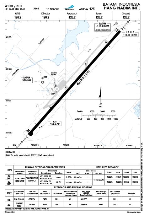
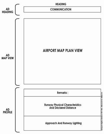
HEADING INFORMATIONs

  • ICAO/IATA Locationidentifier
  • Index Chart number
  • Revision dates
  • Airport elevation in Feet
  • Airport Name
  • Geographic Location City, Country
  • Geographic latitude and longitude coordinates are show in degrees, minutes, and represent the location of the Aerodromes reference point (ARP)

AERODROME COMMUNICATION

  • ATIS (Automatic Terminal Information Services)
  • Director
  • Approach
  • Control
  • Tower (Control tower)
  • Ground
  • Delivery


CHART SAMPLES


AIRPORT MAP PLAN VIEW

  • Visual Runway Markings
    1. Designation
    2. Centerline
    3. Threshold
    4. Aiming Point*
  • Nonprecision
    Instrument Runway Marking
    1. Designation
    2. Centerline
    3. Threshold
    4. Aiming Point
  • Precision Instrument Runway Markings
    1. Designation
    2. Centerline
    3. Threshold
    4. Aiming Point
    5. Touchdown Zone
    6 Side Stripes