Published Qatar Civil Aviation Authority
Produced INDOAVIS NUSANTARA
| Paper Instruction | Products Specification | Notice regarding and Copyright | Chart revisions |
| AC-ICAO Products Specification |
| E-AIP Qatar |
| Current NOTAMs applicable for the State of Qatar |
Aeronautical Chart-ICAO
Civil Aviation Authority (CAA)
State
of Qatar
www.caa.gov.qa
The objective of the Aeronautical Information Service of the State of Qatar is to ensure the flow of aeronautical data and aeronautical information necessary for global air traffic management (ATM) system safety, regularity, economy and efficiency in an environmentally sustainable manner.
The Aeronautical Information Service (AIS) is responsible for the collection and dissemination of aeronautical information for the State of Qatar.
Aeronautical information for the State of Qatar and its territorial boundaries is provided in the Aeronautical Information Publication (AIP) of Qatar and published as Integrated Aeronautical Information Package (IAIP).
-
AIP is the basic aeronautical information document which contains permanent information essential to air navigation within the Doha Terminal Control Area (TMA). It is made up of three parts, namely, General (GEN), En-route (ENR) and Aerodromes (AD).
-
AIP Supplement (AIP SUP) publishes temporary changes of long duration (three months and longer) and information of short duration which contains extensive text and / or graphics, supplementing the permanent information contained in AIP.
-
Aeronautical Information Circular (AIC) contains explanatory or advisory information concerning technical, legislative or administrative matters and on the long-term forecast of major change in legislation, regulations, procedures or facilities liable to affect flight safety.
Valid NOTAMs consists of all current NOTAMs relevant for the State of Qatar (within DOHA TMA) and can be obtained by using the link below.
Contact Details:
Aeronautical Information Service (AIS)
P.O. Box 73
Doha International Airport
State of Qatar.
Tel : (+974) 4465 6558
Fax : (+974) 4465 6554
Email : doha.ais@caa.gov.qa
If errors or omissions of aeronautical data/ information related to the State of Qatar are detected in our published Aeronautical Information Package, please contact us by using above contact details, or transmit the details to OTBDYOYX via AFS.
INTRODUCTION
The
Program in the State of Qatar in Aeronautical Navigation services are required to
publish information in the form of AIP (Aeronautical Information Publication)
as contained in ICAO DOC 8126 (Aeronautical Information Services Manual), One of
the components associated with the navigation service is VFR-AC (Visual Flight
Rules - Aeronautical Chart) with reference to the ICAO (International Civil
Aviation Organization) Doc. 8697 (Aeronautical Chart Manual).
Along with that, the State of Qatar, represented by the CAA (Civil Aviation
Authority), entrusted Indoavis to participate in generating the chart AC-ICAO
Scale 1: 500,000, which has been Indoavis for almost 3 (three) consecutive months, and has
been published on the Qatar e -AIP with address "https://www.aim.gov.qa/"
The results show displayed below
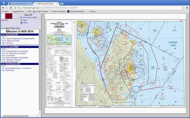
AERONAUTICAL CHART-ICAO
Aeronautical Chart-ICAO cover land areas at a standard size and scale
(1:500,000) for navigation by moderate speed aircraft and aircraft
operating at high altitudes. The topographical information includes city tints,
principal roads, railroads, distinctive landmarks, drainage patterns and relief.
The aeronautical information includes visual and radio aids to navigation,
airports, airways, restricted areas, obstructions and other pertinent data.
These charts are revised and updated annually.
FUNCTION
This chart shall provide information to satisfy the requirements of visual air
navigation for low speed, short- or medium-range operations at low and
intermediate altitudes.
Note 1. This chart may be used:
o to serve as a basic aeronautical chart
o to provide a suitable medium for basic pilot and navigation training
o to supplement highly specialized charts which do not provide essential
o in pre-flight planning.
Note 2; It is intended that these charts be provided for land areas where charts
of
this scale are required for civil air operations employing visual air navigation
independently or in support of other forms of air navigation.
Note 3; where States produce charts of this series covering their national
territories, the entire area being portrayed is usually treated on a
regional basis.
Availability
Recommendation; The Aeronautical Chart — ICAO 1:500 000 should be made
available in the manner prescribed in 1.3.2 for all areas delineated in Appendix
5.
RESPONSIBLE SERVICES
The authority responsible for the production of aeronautical charts is the
Assistant Director General of Civil Aviation (Air Traffic Management), acting
under the authority of the Director- General of Civil Aviation.
Aeronautical charts have been prepared in accordance with the standards and
recommended practices of Annex 4 - Aerodrome Charts, and the guidance material
in the ICAO Aeronautical Charts Manual (Doc 8697 - AN/889/2).
a. Copyright by : Qatar Civil Aviation Authority
b. Publication by : Qatar Civil Aviation Authority
c. Data compilers by : Indoavis Nusantara
d. Production by : Indoavis Nusantara
e. Product Maintenance : Indoavis Nusantara
Type of VFR Aeronautical Chart
The scope of CAA needs navigation operations, VFR maps include the following types, listed below
| No. | Code | Products Name | Type | Physical product | Scale | Coverage Areas |
| 1. | AC | Aeronautical Chart-ICAO | VFR | Hardcopy & Softcopy | 1:500.000 | State of Qatar |
SOURCE DATA
Aeronautical information is made available via the Integrated Aeronautical Information Package (IAIP) that includes the State Qatar Aeronautical Information Publication (AIP), Circulars (AIC), AIP Supplements and NOTAM, all compiled from numerous and often unique sources of data. Indoanis Nusantara focuses on data originators, and the processes that are necessary to ensure consistency and quality levels throughout the aeronautical data management chain.
-
AIP (Aeronautical Information Publication) Permanent information which is only issued by each member State of ICAO
-
AIP AMDT (Amendment) Permanent changes to the information in the AIP.
-
AIP SUPP (Supplement) Temporary changes to the information in the AIP are published through a special sheet sheet
-
NOTAM (Notice to Airman) A notice distributed by Telecom which contains information about the existence, condition or change in certain Aeronotic facilities, services, procedure or danger, you need to know early on by personnel associated with flight safety.
-
GISQATAR.org.qa GIS Center of the Ministry of Municipality and Urban Planning, has identified the Emiri Decision No. (36) for the year 2009 sections and terms of reference of the center so that consists of five sections, a section topographic survey, the Department of Services maps and archiving, Department of Planning and Projects, Department of ecosystem services, and the terms of reference of the center are :
The provision of basic geographical maps of the state and related services in coordination with the competent authorities in the country -
SRTM 30M (The Shuttle Radar Topography Mission) is an international research effort that obtained digital elevation models on a near-global scale from 56° S to 60° N,[2] to generate the most complete high-resolution digital topographic database of Earth prior to the release of the ASTER GDEM in 2009. SRTM consisted of a specially modified radar system that flew on board the Space Shuttle Endeavour during the 11-day STS-99 mission in February 2000, based on the older Spaceborne Imaging Radar-C/X-band Synthetic Aperture Radar (SIR-C/X-SAR), previously used on the Shuttle in 1994.
AERONAUTICAL DATA
-
AIP (Aeronautical Information Publication)
AIP used by INDOAVIS in generating AC-ICAO-1: 500,000 is eAIP Bahrain web address (http://bahrainaims.com/aisjan2014/2014-02-06-AIRAC/html/index-en-BH.html), with effective 06 FEB 2014 Issued by the State Kingdom of Bahrain.
-
POINT DATA REFERENCES Source data Aerodrome (ARP), Navigation Aids (VORDME, NDB, VORTAC) Aerodrome and Runway Elevation and dimension of data are obtained from AIP , the recorded airports are as much as 7 (Seven) Airports that is :
-
1. (OBBI) BAHRAIN INTERNATIONAL 06 FEB 2014
-
2. (OBBS) BAHRAIN / ISA AIRBASE 06 FEB 2014
-
3. (OBKH) BAHRAIN / SAKHIR AIRBASE 06 FEB 2014
-
4. (OTBD) DOHA INTERNATIONAL 06 FEB 2014
-
5. (OTBK) AL KHOR 06 FEB 2014
-
6. (OTHH) HAMAD INTERNATIONAL 06 FEB 2014
-
7. (OTBH) AL-UDAID SUPP (19/2013)
Note: For airport DHAHRAN (Saudi Arabia) and Dalma (United Arab Emirates) are obtained from WAC-ICAO map sources code 2547, 2004 Bahrain scale 1:1,000,000. Navigation and maps contained in the AIP PDF files, such as: Aerodrome Index Chart, Radio Facility Index chart, Area Chart Edition 9.1.2014
-
- POLYGON DATA REFERENCES
For data sources, and special use airspace, the Airspace Data are taken from ENR5.1 AIP-2 s / d 1-4, ENR 2.1 FIR, UIR, TMA, CTA edition of 6 February 2014, and for terminals acquired from the AD 2:17 Airspace ATS airspace at each respective airports.